|

|
|
Rakesh Baidya | baidyarakesh@gmail.com
|
Eco-Tourism Map of Uttarakhand-Information Design: Map Making
|
Guide Rupesh Vyas
Sponsor Arch i platform
|
|
| |
 |
Keywords colouring;eco-tourism;non-detail in colour;Uttarakhand
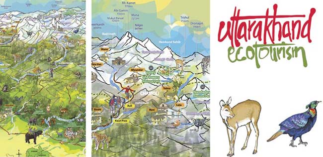
This project focused on designing a map for the state of Uttarakhand with the theme of eco-tourism for the Forest department of Uttarakhand, World WildLife Fund, (WWF) India, and the Himmothan Society run by Sir Ratan Tata Trust.
The map highlighted the ecological wealth and biodiversity of Uttarakhand and showcased the yearly development of eco-tourism projects. This map shows a perspective of the state with the majestic peaks of Nanda Devi, Dronagiri, Mana, and Kedarnath in the back ground; the plains of the Terai in the foreground, coinciding with the Ganga, Bhagirathi, Kosi, and Kali rivers. The unique flora and fauna of the state have been illustrated in the appropriate areas. Various eco-tourism activities have been indicated to encourage low footprint eco-friendly travel habits.
The reverse of the map highlights twelve key locations where the local communities, together with various organisations have encouraged and successfully implemented ecology and community based tourism practices. The colouring is done in patches to justify the concept. The borders of the state were merged taking a non-political stand. Thus, the separation of the state boundaries from neighbouring states and countries was done with non-detail in colour and information on non-representative areas.
The project was a great learning experience due to the collaboration with professionals from different fields, and the ability to justify ones design decisions. It was a true test of functional graphic design and was also about finding a balance between science and art. |
|
|